Last winter, one of the coldest and snowiest on record, about 150 Detroiters took to the streets. Using an app created by
Loveland Technologies, they visited and documented the condition of each of the city's 375,000 parcels, creating what is likely the most comprehensive database of one city’s property in the nation.
But before they hit the streets, an unprecedented collaboration of individuals and organizations was required to get what has come to be known as the
Motor City Mapping (MCM) project off the ground. That collaboration continues as MCM data is translated into vital public information that will be used for years to come by a variety of users, including city departments, community groups, nonprofits, and investors.
For three organizations contributing to Motor City Mapping –
Detroiters Working for Environmental Justice (DWEJ),
Data Driven Detroit (D3), and
Focus: HOPE – this kind of collaboration was the natural result of an ongoing relationship. Each organization participates in Wayne State University's
Detroit Revitalization Fellows (DRFP) program, which pairs emerging urban leaders from across the city and the nation with organizations contributing to the civic, community, and economic development of Detroit.
Three fellows, Sandra Yu Stahl (DWEJ), Diana Flora (D3), and Jerrell Harris (Focus: HOPE) put their network to use to help drive Motor City Mapping – before, during, and after the initial data were collected.
Meeting challenges, engaging community
With a degree in city planning from the Massachusetts Institute of Technology and several years' experience working as DWEJ's senior manager for strategic initiatives, Yu Stahl was a natural fit to lead Motor City Mapping's community engagement efforts.
"I helped set up community meetings, answered questions from the public and did some training on how to use the survey," Yu Stahl says. "One of the things that the Motor City Mapping project did was help connect the public to agencies that could help them."
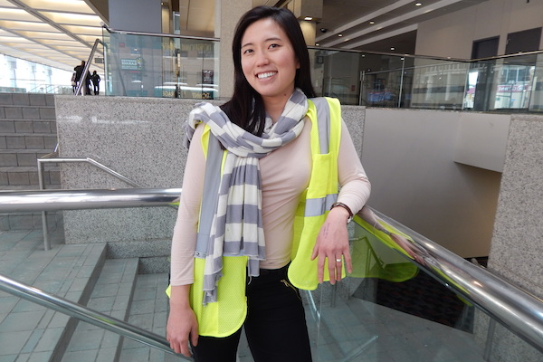
![]() Sandra Yu Stahl of Detroiters Working for Environmental Justice at Cobo Center
Sandra Yu Stahl of Detroiters Working for Environmental Justice at Cobo Center
She says one of the biggest challenges the group faced was to bring groups and individuals together, many for the first time.
"For some people in the community, as well as nonprofit groups and for-profit business interests, this was a new kind of partnership," says Yu Stahl. "We wanted to make sure everyday Detroiters were included and that this all had value for them. We want people in the neighborhoods to help update the data. They have an important role."
The information they continue to generate will help the city as it makes strategic decisions about demolition of blighted properties, Stahl says, and will assist the county as it makes even more difficult decisions regarding foreclosed properties.
"The best thing about (the mapping effort) is that it is a citywide project that involves everyone in Detroit," she says. "There is great cooperation from bottom to top, we are continuing to improve the technology and keep the data fresh. It's a cool, inspiring thing, something that can work for the benefit of all for years to come."
Driving the data
Of course, all of this only works if the collected data are accessible and understandable to everyday Detroiters.
That's where Diana Flora, a project manager at Data Driven Detroit, comes in. She describes her job as involving "execution, synthesis and analysis of data."
"It's about bringing certain things to light," Flora says. "The data showed that half of the foreclosed homes in the survey were occupied. That's a critical piece that needs to be known."
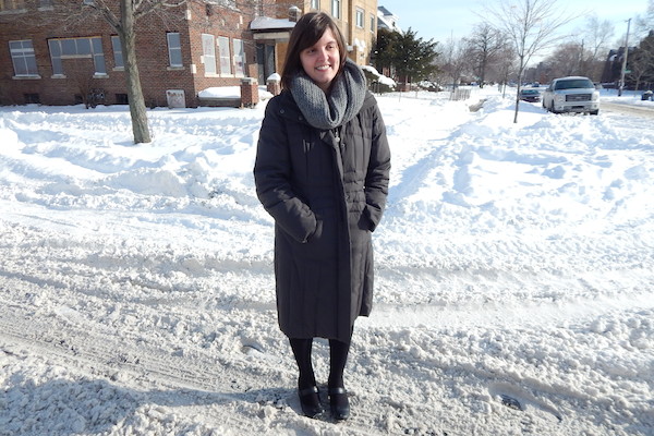
![]() Diana Flora of Data Driven Detroit at the LEED house
Diana Flora of Data Driven Detroit at the LEED house
Flora, a Bay City area native with degrees in policy and urban planning from the University of Michigan, says that Motor City Mapping has powerful implications locally, but also has national relevance.
"Once word started to spread about Motor City Mapping in the national news, we started being approached by municipalities across the country that are interested in replicating the process," she says. "Though Detroit may seem unique in its challenges, other cities are experiencing similar issues, and Motor City Mapping is a way to provide a data-driven framework for understanding those challenges.
"(It) sparked a conversation about how open data can drive decisions for everyone," Flora says. "We may see this type of project spark demand for more data transparency in other areas -- like education, the city's budgetary information, and so on -- from both residents and city officials."
Flora attributes much of the project's success to support from the network of Detroit Revitalization Fellows.
"The Fellows network played a crucial role in every step of the process," she says. "In the very beginning, when faced with the daunting question of how we could recruit over 120 Detroiters on short notice to work with us on this survey, all I had to do was call the fellow placed at the
Detroit Employment Solutions Corporation (DESC), who successfully recruited an incredible amount of people for us in a very short window of time.
"Along the way, many fellows offered input on our analysis, providing their diverse perspectives from organizations across the city."
Attacking blight, stabilizing neighborhoods
As Focus: HOPE’s placemaking and planning manager, Jerrell Harris's work is largely focused within the 100-block
HOPE Village Initiative area. A Georgia native with a background in sociology and urban planning and policy, Harris uses placemaking strategies to encourage housing rehabilitation, and he is making use of Motor City Mapping data to inform his organization's investment decisions.
One of his major projects is redeveloping an old house on LaSalle Boulevard just south of the Focus: HOPE campus into Detroit's first certified
LEED Platinum residence. When completed this summer, the home will feature a residential second floor and a demonstration area on the ground floor. A partner for this project is the New Orleans-based
Make It Right Foundation, which was founded by Brad Pitt in 2007 to develop sustainable housing in neighborhoods that were devastated by Hurricane Katrina.
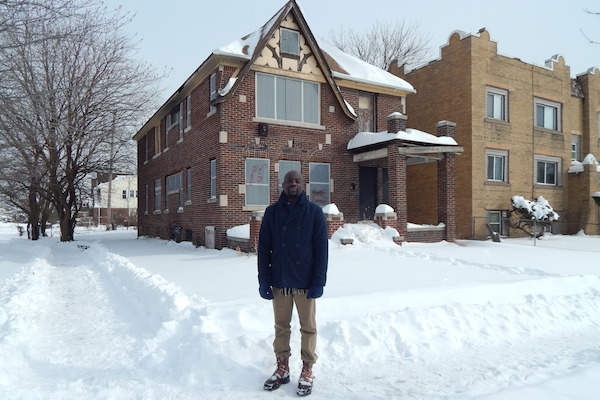
![]() Jerrell Harris at the LEED house in progress in HOPE Village
Jerrell Harris at the LEED house in progress in HOPE Village
.jpeg)
![]() Map of property conditions in HOPE Village
Map of property conditions in HOPE Village
"I see this as a unique opportunity to rebuild a neighborhood," says Harris. "There is no better place to put a LEED house than in HOPE Village. It's a microcosm of the city. Our 20-year goal is to create a safe, supportive environment, something that can be replicated across the city."
Harris says that the 100-block village will host a three-day anti-blight event in July, when volunteers will board up houses, clean up vacant lots and begin beautification efforts as part of what he calls "a transformative plan for the neighborhood" that is greatly informed by MCM data.
The LEED Platinum house is scheduled for completion in July – the same month that Harris will finish his two-year commitment with the fellowship.
What has he learned so far from his 19 months working in the city?
"Detroit hustles harder, this is true. You can be extremely creative here, push the envelope, and build something here," Harris says. "There is great opportunity to get professional work done. We can do things here that other cities are afraid to do."
Support for this series is provided by Detroit Revitalization Fellows, a program of Wayne State University. This is the final article in a four-part Model D series. Read other stories in the series here. Detroit Revitalization Fellows is currently recruiting for its third cohort. The application period is now open. Finalists for the next cohort will be selected March 30 - April 2. Go here to learn more.
---
Words and pictures by Walter Wasacz