Illustration of a mastodon in Michigan. Creative Commons
Michigan is famous for its mitten shape. But without the thumb, we'd be nothing but a sock.
According to John Zawiskie, a geologist at Cranbrook Institute of Science, the Great Lakes basins and Michigan's shape, including the Thumb, were the result of fractures in the bedrock and ice age scouring of the bedrock layers by multiple advances of continental glaciers
—at least six during the last 780,000 years of the Ice Age. The gently folded rock layers of the entire Lower Peninsula are technically a structural basin, comparable to a series of nested mixing bowls.
The weaker bands of rock were stripped away by the glacial ice that flowed around and over the more resistant formations, creating the Thumb, Saginaw Bay, and the southern Lake Huron basin. And that was a relatively recent aspect of the geologic history of our favorite digit.
As the ice in the Thumb melted away, the Huron and Saginaw lobes separated along a northeast-to-southwest axis. Sediments were deposited in the growing area in between them. At the terminus of those lobes, long moraines were formed, including the Port Huron Moraine, which extends in a U-shape from Port Huron to Bad Axe to Cass City.
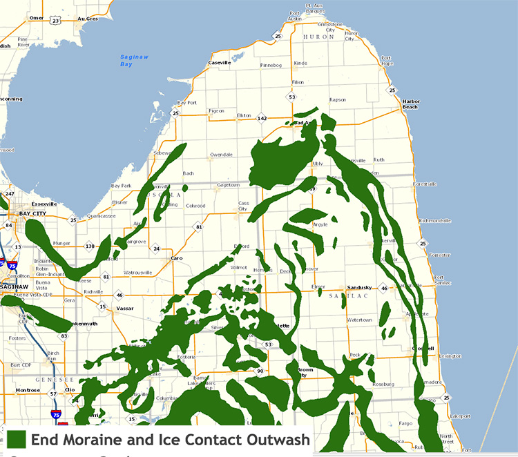
![]() On the western side of the Thumb, retreating glaciers deposited their sediment loads directly into lakes, forming moraines on top of the old lake plain. This creates significant relief which can be viewed south of Bayport along M-25, east of Sebawaing.
Parallel to the Lake Huron shoreline, ancient beach ridges of former shorelines of the prehistoric Great Lakes can be found as elevated ridges on the landscape and sandy veins in the soil.
Land use locally reflects this glacial geology, which gave rise to the soils we have today. Most of the perimeter of the Thumb is a flat lake plain with poorly drained clay soils. These areas have been drained and put largely into row-crop agriculture. The interior of the Thumb is characterized by more diverse, well-drained soils born from glacial moraines and outwash. They support a more diverse land cover with some remaining intact forests and diverse agriculture ventures, including the new trend of growing wine grapes along the Port Huron moraine.
As the glaciers subsided, the Thumb was inhabited by Pleistocene creatures such as the mammoth and mastodon, and their bones can still be found buried in the glacial sediments today. "It's not an unusual thing to find megafauna going all the way up through the thumb," says Zawiskie.
On the western side of the Thumb, retreating glaciers deposited their sediment loads directly into lakes, forming moraines on top of the old lake plain. This creates significant relief which can be viewed south of Bayport along M-25, east of Sebawaing.
Parallel to the Lake Huron shoreline, ancient beach ridges of former shorelines of the prehistoric Great Lakes can be found as elevated ridges on the landscape and sandy veins in the soil.
Land use locally reflects this glacial geology, which gave rise to the soils we have today. Most of the perimeter of the Thumb is a flat lake plain with poorly drained clay soils. These areas have been drained and put largely into row-crop agriculture. The interior of the Thumb is characterized by more diverse, well-drained soils born from glacial moraines and outwash. They support a more diverse land cover with some remaining intact forests and diverse agriculture ventures, including the new trend of growing wine grapes along the Port Huron moraine.
As the glaciers subsided, the Thumb was inhabited by Pleistocene creatures such as the mammoth and mastodon, and their bones can still be found buried in the glacial sediments today. "It's not an unusual thing to find megafauna going all the way up through the thumb," says Zawiskie. "
Bones and teeth from at least seven different mastodons and at least one mammoth have come out of the Thumb area, most recently a spectacular specimen called the Fowler Center Mastodon was excavated by the University of Michigan."
Going back about 400 million years ago during the Mid-Paleozoic Era, Michigan was located in the tropics and covered by shallow, warm seas analogous to those found in the Caribbean today. During this period, sedimentary bedrock was deposited in the form of limestone, shales and sandstone into the subsiding Michigan Basin.
The Paleozoic bedrock beneath the glacial sediments running down the central axis of the thumb features the Marshall Sandstone Formation, which can be seen cropping out along road cuts in the area. A visit to the tip of the Thumb, especially at Pointe Aux Barques, reveals great exposures of the sandstone, including the well-known Turnip Rock in the Saginaw Bay. Similar erosional features can be found along Pictured Rocks in Michigan's Upper Peninsula.
"The Marshall Sandstone is a major aquifer, and also, of course, at one point was a very important source of sandstone. It's the main structural unit that supports the Thumb itself," says Zawiskie. "The rocks originally formed in shallow tropical seas and range in age from about 320 to 358 million years. Right at the very tip of the Thumb is a place called Grindstone City, where many old quarries once existed. The sandstone made fantastic millstones, for grinding grain and were sold as far away as Europe."
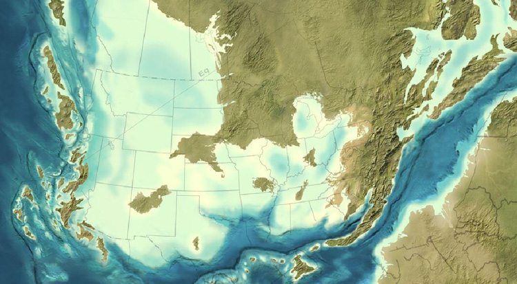
![]() Note Michigan is just south of the equator and covered by a shallow sea.
Moving westward and higher in the rock sequence, one passes over the shallow sea deposits of the Coldwater Shale, Michigan formations and Bayport Limestone Formation. The area is home to the Wallace Stone Quarry in Bayport.
As for oil and gas activity, the Thumb's bedrock doesn't support much of it.
"There's minimal oil and gas drilling across most of the Thumb with the exception of the area right outside of Port Huron, which is underlain by the oil-rich Antrim Shale," says Zawiskie.
Here are some geologic points of interest you can check out in Michigan's thumb:
Note Michigan is just south of the equator and covered by a shallow sea.
Moving westward and higher in the rock sequence, one passes over the shallow sea deposits of the Coldwater Shale, Michigan formations and Bayport Limestone Formation. The area is home to the Wallace Stone Quarry in Bayport.
As for oil and gas activity, the Thumb's bedrock doesn't support much of it.
"There's minimal oil and gas drilling across most of the Thumb with the exception of the area right outside of Port Huron, which is underlain by the oil-rich Antrim Shale," says Zawiskie.
Here are some geologic points of interest you can check out in Michigan's thumb:
- Turnip Rock in Saginaw Bay at Pointe Aux Barques
- Sanilac Petroglyphs Historic State Park, 8251 Germania Rd, Cass City
- White Rock (Paleozoic bedrock) at foot of Atwater Road in Lake Huron
- End moraines along Van Dyke south of Bad Axe. North of Bad Axe, watch for road cuts with exposed sandstone bedrock
- Exposed limestone along the Saginaw Bay near Bayport
- Grindstone City quarries, local road cuts and shoreline
You can learn more about the geology of Michigan's Thumb in this video clip, excerpted from Cranbrook Institute of Science's Geology of Michigan series.
Enjoy this story?
Sign up for free solutions-based reporting in your inbox each week.

Nina Ignaczak is a metro Detroit-based writer and the editor of
Metromode. Follow her on Twitter
@ninaignaczak.