How metro Detroit communities are slimming down with road diets
Road diet have become a popular way for city planners to calm traffic and add non-motorized transit options in metro Detroit. But are they just fad diets? Or do they actually carry benefits for commuters and communities?
Transportation planners call the act of slimming down a street or highway a “road diet.” Sometimes they use it to add features like turn lanes or bike lanes. Other times they use the technique simply to slow down traffic. Lately, road diets are on the rise as a tactic by Michigan communities to transform the way we get around. But are they just fad diets, or do they carry benefits for commuters and communities?
A 2012 Michigan Department of Transportation analysis of four to three-lane conversions by the state of Michigan found, in almost all instances they studied, that crashes declined over time. The study also noted that as part of a broader plan they could open up traditional roads to greater use by pedestrians and bicyclists.
To get a better picture of what road diets mean for folks on the street, we spoke to surveyed several metro Detroit municipalities to get their perspective on how cutting down on lanes has impacted their communities.
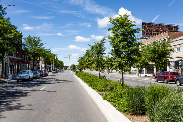
Detroit: Creating inclusive roads
The Motor City has been generating a lot of buzz over the last few years for embracing new approaches to reconfiguring its roadways. Perhaps the most attention-grabbing aspect of this work has been its bike lanes. Detroit has installed over 200 miles of bike lanes in neighborhoods all across the city since 2011.
The new cycling infrastructure has included restriping to indicate lanes — both straightforward bike lanes and buffered lanes with some extra spacing to keep cars and cyclists apart, protected lanes featuring vertical posts called bollards to physically separate bikes and motor traffic, and green-paint near traffic signals to draw attention to the presence of cyclists.
Protected lane projects along Cass and East Jefferson avenues have been the source of some controversy due to their use of bollards as well as other design and maintenance issues. New lanes can also be found on Michigan, Livernois, Grand River, and West Vernor Highway, to name just a few more thoroughfares that have been revamped to be more inclusive of cyclists.
While this reworking of Detroit’s streetscape has involved the elimination lanes to make room for bikes and other modifications like on-street parking, Ron Brundidge, director of the city of Detroit’s Department of Public Works, rejects the use of the term “road diet” to describe these kinds of projects.
“The objective is not to ‘slim down’ the road by simply reducing travel lanes,” he says. “Instead the purpose is to redesign streets in a manner that maximizes safety, while recognizing that public right of ways are to be built in a manner that allows for safe and efficient use by all modes of transportation, including pedestrians, bicyclists, vehicles, and transit.”
This outlook reflects a Complete Streets approach to road design, where all potential users are taken into consideration when building or modifying a roadway. Detroit has been assisted in its work by advocacy groups like the Detroit Greenways Coalition, a member of the city’s Non-Motorized Transportation committee, which helps city planners in their efforts to maximize the use of the public right of way while incorporating Complete Streets principles in their work.
According to Brundidge, the city’s recent road redesign efforts have made corridors safer by reducing vehicle speeds and decreasing the distance pedestrians have to travel across moving vehicle lanes. While there has been a bit of a learning curve for residents and commuters, he’s confident that their outlook on the road modifications will improve as people start to get a clearer understanding of the city’s objectives. That, however, depends on the city and supporters taking an active role teaching people about the benefits of bike lanes and other road enhancements.
“Community outreach and education are as important as the actual design and implementation of the infrastructure,” he says.
The DPW director recognizes that several of its projects, like the redesign of East Jefferson Avenue, didn’t incorporate an adequate level of outreach and education in the past, but he says going forward the city plans to make that a priority prior to the “first markings being installed in the pavement.”
That said, he is a firm believe in the benefits of taking a Complete Streets approach to road design. “These projects make our roads safer for all users,” he says. “They offer high value improvements at a relative low cost. As a result, there is always an option to restore the road to its prior configuration if the design does not work as planned.”
Birmingham: Selling a diet to a skeptical public
In 2015, Birmingham commuters and residents got a first-hand taste of what a road diet can do when the city slimmed down a portion of West Maple Road. Following a recommendation from the city’s multimodal plan, Birmingham’s city commission voted that summer to temporarily revamp a 1.3 mile stretch of the road between Southfield and Cranbrook, hoping to slow traffic and make travel safer along the corridor.
Under the pilot program, that segment of Maple — located in a largely residential area of Birmingham — was restriped from four to three lanes with a center turn lane nestled between two traffic lanes. Bike lanes were also part of the temporary redesign.
The road diet went live in the fall of 2015. Despite the confidence of city officials, though, residents greeted the changes with vocal opposition.
“It was no easy challenge,” recalls Birmingham city planning director Jana Eckert. “It was counterintuitive for folks to understand that narrowing a road could assist with congestion and safety by lowering speeds and lowering the severity and number of accidents. People were concerned that this was going to stop traffic dead and people wouldn’t be able to get off side streets.”
But city planners stuck to their guns, and when it came time to make a permanent decision the following year, they had numbers to back them up. A study conducted by the research firm Fleis & Vanderbrink showed that accidents along the roadway had decreased a total of 38 percent, while the average speed was reduced and cut-through traffic declined. With the exception of two streets, overall traffic volume remained unchanged.
Ultimately, the city commission decided to keep the three-lane configuration but chose to ditch the bike lanes.
“At the time bike lanes were just a little too much change,” says Eckert, “As it stands, there is a four-foot shoulder with a strip that shows it’s not part of the lane. So you could ride your bike there, but it is not an official bike lane.”
Eckert says Birmingham residents have developed a more positive outlook on the changes to the road over time.
“We have slowed the complaints and get mostly positive feedback now,” she says. “I can’t tell you how many people have called and said, ‘You know what, this is working great. I can’t believe it, I don’t understand it, but I love it.”
Romeo: Inviting people in with a calmer road
If Birmingham does a good job of giving a birds-eye-view of what a road diet might look like in a densely populated suburban setting, Romeo offers a glimpse at what it can look like in a more rural area. The village of Romeo, located in the northwest corner of Macomb County, underwent a road diet on East St. Clair (also known as 32 Mile) in 2016.
Running from Main Street (Van Dyke) to Clinton Road, the reconfiguration was part of a repaving effort by the county. The project reduced the roadway from four lanes to three, with two traffic lanes and a turn lane. A wider sidewalk was also added on the north side of St. Clair.
Although the cost of the project was shared by the village of Romeo and Macomb County, the county spearheaded the project. John Crumm, planning director of Macomb County’s Road Department, says there were both practical and aesthetic reasons for the road diet.
There’s the safety factor, three-lane roads with turn lanes tend to be safer than four-lane roads. The County also wanted to provide some space in the future to connect Romeo to the Macomb Orchard Trail, the main multi-use hiking and biking trail in the area. But beyond that, county road officials also wanted to give visitors a chance to slow down and take in the scenery.
“We wanted to it have more of a look and feel of moving into a village, rather than a road that is a way of getting out of the village,” he says. “Kind of an invitation to stop and see what’s going on in Romeo.”
Mike Lee, Romeo’s city clerk and administrator, says the road reconfiguration has been mixed for the village. He likes the look of it but says it’s also led to traffic jams.
“All of our parking is in the back of our properties in the village of Romeo,” he says. “So when the turn lanes are full, the only lane they can turn into the back parking location backs up at the lights and that creates a stopping point for everybody else.”
While this can be a problem for out of towners, especially trucks passing through, locals know to use side streets.
“If you live in the community, you know what’s going on, and you have to take that into account,” says Lee. “The way we have it looks nice, and it’s great right now.”
Royal Oak: The road diet connoisseur of metro Detroit
Royal Oak in Oakland County is no stranger to road diets. The city has tried several over the last few years and is now in the process of implementing more.
In 2016, Royal Oak conducted a pilot along two stretches of Main Street, between I-696 to Seventh Street and between 11 Mile and Catalpa, reducing them from four to three lanes and five to three lanes, respectively, and adding bike lanes.
Although the lanes did succeed at slowing traffic speeds by about five miles an hour, commuters resented the new configuration and longer waits at lights. Many simply acted as if the bike lane striping was invisible.
“A lot of people disregarded the striping,” says Matt Callahan, Royal Oak’s city engineer. “They just drove down the road as if the bike lanes did not exist, which is dangerous for cyclists. We had cyclists who were riding the wrong way. We had a lot of things that were not working well with it.”
Additionally, there were concerns among some elected city leaders that reducing the lanes would endanger several commercial developments. For these reasons, the city commission chose to forgo permanent road diets on those sections of Main Street.
But the city has been listening to voices in the cycling community. Cyclists are clamoring for a designated route to get from the south end to the north end of Royal Oak. For this reason, the city is now moving to create a route that includes sections of Washington Avenue and northern Main Street with Euclid as a connector. The plans call for reducing lanes and adding bike lanes with buffering in some parts and keeping sharrows — street markings indicating the road should be shared by cars and bikes — in other areas where it makes sense, like a stretch of road that features angled parking.
Choosing Main Street for the northern part of the route makes sense, says Callahan, because it provides access to Clawson. And using Washington to the south makes sense because it does a great job helping cyclists link up from I-696 and Woodward Avenue, and it isn’t being used all that much by motorists.
“Have you heard the term ‘Stroad’?” Callahan says about Washington. “Is it a street or a road? It was a Stroad. It served no purpose for being a 70-foot wide strip of pavement with the traffic it had. So we kept saying Washington is the best place to do this.”
As if that’s not enough road dieting, Royal Oak is also planning another diet for Campbell between Hilton Road and Fourth Street. Installed as part of a federal road resurfacing project, the new diet will reduce four lanes to three and feature a turn and bike lanes. Local cyclists will no doubt be excited to learn that the new configurations will connect Ferndale’s bike route on Hilton with the existing lanes on Fourth Street in Royal Oak.
While it might seem that Royal Oak has been going a little head over heels with road diets at the moment, Callahan recognizes it’s important to study the traffic conditions and context of an individual road before slimming down lanes and rushing into a new configuration.
“In urban areas, it does come down to the fact that road diets work well on based on traffic,” he says. “If you have a lot of driveways and critical intersections with traffic signals, you have to pay attention to those things when you’re designing them.”
Author

Related Articles

Driving innovation: Corktown tech hub welcomes inaugural cohort of state’s Mobility Fellows Program
“These 10 Fellows represent a bright future as we work together to support startups, tackle mobility challenges, and provide transportation solutions for Michiganders across the state,” says Justine Johnson, Chief Mobility Officer for the State of Michigan.

From Corktown to 8 Mile: Two major Detroit redevelopment projects receive design awards
“The awards are a wonderful recognition of our hard work and what we see every day at the park; people that are engaged and enjoying the beautiful gardens and settings of this unique, historic park and neighborhood asset,” says Jeff Klein, Deputy Chief of Landscape Architecture City of Detroit General Services Dept.

Detroit seeks innovators with ‘bold ideas’ for curbing freight pollution in Eastern Market
"As the only city chosen in the western hemisphere, Detroit represents over one hundred years of world-renowned innovations in transportation,” says Tim Slusser, Chief of the City of Detroit’s Office of Mobility Innovation.
