Art of walking: Going the distance in Detroit’s inner space
Steve Panton, originally from Nottingham, England, lived in New Zealand before settling in Detroit in the 1990s. He runs the 2739 Edwin art space in his Hamtramck loft, where he exhibited a splendid show called Walking Distance in 2009.
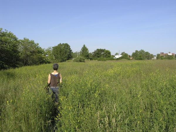
Detroit would be perfect if only it had hills. Even a small incline, just enough to get the heart rate up and change the horizon a little. But if not contour, it does have sidewalks, interest aplenty and space enough to allow walks of almost any length.
There is a misconception that people don’t walk in Detroit. What creates the paths that run across almost every empty lot in the city if not human feet? The reality is that you can go all over the city and see people walking in more density than almost any other area in metro Detroit. It’s a city with low car ownership and poor public transport; what else can you do?
In Wanderlust, her great book on the history of walking, Rebecca Solnit speculates that walkers are a type of indicator species, a biological species that designates a trait or characteristic of an environment. From her perspective walking implies “various kinds of freedoms and pleasures: free and alluring space, and unhindered bodies.” In Detroit, as always, the situation is more nuanced. Walking can stand for those things, or it can stand for the opposite.
The most “walkable” areas in Detroit are often taken to be those lying in a ring around the center of the city: the historic districts of Woodbridge, Corktown, the Eastern Market, Southwest Detroit, Midtown, the Cass Corridor, the Riverfront, Lafayette Park, and the enclave city of Hamtramck. Since these areas are virtually contiguous they allow for walks that can easily fill up a day.
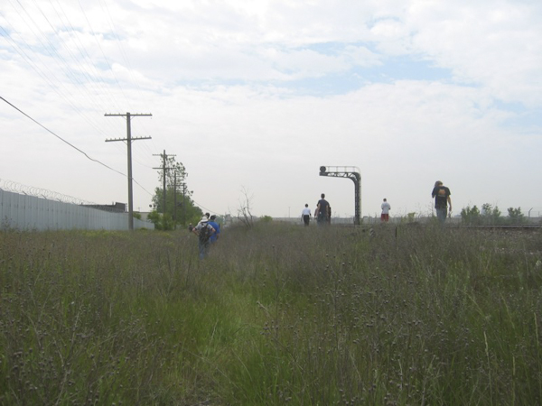
My favorite walk is one that with various permutations I have been expanding and evolving for over 10 years. In its current form, it starts in Hamtramck and heads south to Milwaukee Junction behind Russell Industrial Center, then heads southwest alongside the train tracks before heading south on either Third, or Rosa Parks Boulevard. Eventually it works its way through Woodbridge and Corktown down to the river. Sometimes I take Bagley to Southwest Detroit, if I need to go there, a much pleasanter route since the construction of the new footbridge over I-75.
Eventually I either cut through downtown, or follow the river to Lafayette Park, then head up to Eastern Market. From here I cut across to Brush Park then head north to pick up the train tracks again and head back to Hamtramck. It’s basically a grand tour of those areas mentioned ringing the center city. It would be pointless to try here to describe the history and range of experience that a circuit like this traverses; it could easily fill a book. But I can give a very brief overview and touch on a few other things.
History is everywhere
The section along the tracks from Milwaukee Junction is a standout, an elevated walkway through what remains of the old automotive district. Milwaukee Junction itself predates any surrounding buildings, being formed in the late 1850s from the junction of the Detroit and Milwaukee and the Chicago, Detroit and Canada Grand Trunk railroads. The industrial architecture, including the storied Piquette Avenue plant is fantastic, the views are outstanding and history is everywhere. Until the fire at the Studebaker plant there was a painted sign advertising EMF, a former automaker that became defunct before the first World War.
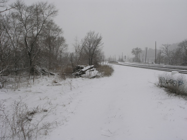
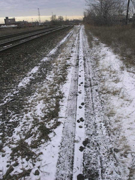
For me winter is the best time to walk in Detroit. A few inches of snow on the ground gives a better workout and there is an anonymity that comes from being bundled up in Carhartt, hat and gloves. Walking through a heavy snowstorm is an experience in itself. For a brief period of time the snowdrifts bring everyone down to the same level of struggle, although at the end of it some have the option to return to heated homes and others don’t.
Later, after the storm is over and things have returned to normal, different animal tracks start to appear in the snow. As well as being fascinating studies in urban nature, they also gives an insight into where the wild dogs are most present. Dogs in Detroit are best not taken lightly and the section of track between Third and Rosa Parks, in particular, is serious dog territory. But near this area is a sort of oasis where the steam pipes run close to the surface of a grassed area, keeping it warm and free of snow. Even in the depths of winter the bird call sounds like spring.
Heading south through Woodbridge and Corktown leads to the mighty Detroit River. There is another great myth that Detroit doesn’t value the waterfront. In my experience it’s almost impossible to keep Detroiters away from the river. When areas of the waterfront are fenced off, for example around the docks area or the old Uniroyal plant, fence holes quickly appear, allowing access to walkers and fishermen. If people are actually encouraged to walk, as they are with the new Riverwalk, the resulting crowds have been predictably large. The planners’ ultimate vision is to establish a walking path from West Grand Boulevard to Belle Isle; in reality you can pretty well do that now, with a few diversions and short cuts.
One area of the waterfront that has become less accessible is the area under the Ambassador Bridge which was fenced off some time after 9/11. A few times a year the river will lie under a temperature inversion that causes a dense mist to linger through the day. It seems particularly magical at that time.
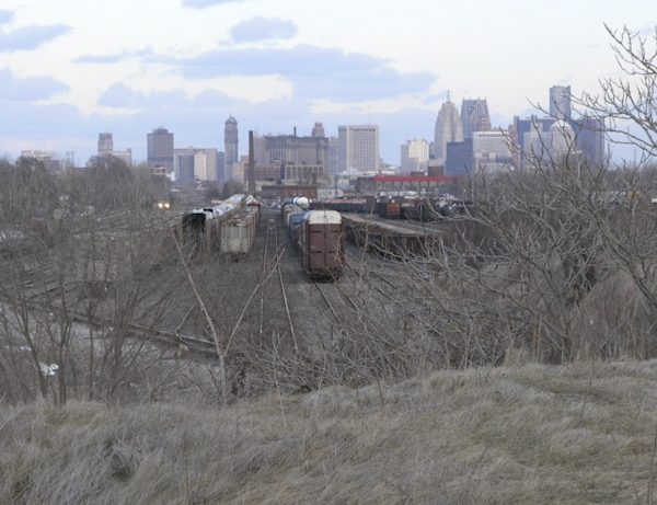
Heading north parallel to Woodward Avenue leads you back to the Milwaukee Junction area. From here the train tracks leading back over Grand Boulevard and I-75 should see you back to Hamtramck in 45 minutes or so. A couple of years ago a friend and I saw a Coyote just east of Woodward and I’ve kept an eye out for tracks since then without success.
“Mingling of the errand and the epiphany”
I find it’s rarely hard to find a good excuse to go on all, or part of this walk; there’s almost always some place to visit along the way. In fact, I like the enforced change that comes to the route when it has to include, say, dropping by someone’s home on the Southwest side. To me it’s a given that a by-product of a planned walk will be some unexpected insight into the city, and there’s a beauty in that. Solnit recognizes this more poetically when she describes the magic of the street as being “the mingling of the errand and the epiphany.”
Detroit seems perfectly scaled for this, its shops, restaurants and residences at first appearing isolated, but in reality are easily joined by walking. It’s not too much of a stretch to see it as a scaled down version of the landmarks and watering holes of indigenous Australian songlines; and there’s a parallel here too in the non-rational association to place that Detroit’s deep emotional charge seems to produce in people.
Sometimes an unexpected remark or event has led me to study things more deeply. For example, a chance comment on an Albert Kahn bank building near the boulevard caused me to photo some 120, or so, former bank buildings around the city. It became an extended meditation on permanence, transience and the flight of capital. Or the sudden attempt to fence off a green space became a multi-year reflection on fear, control and nature. In her Metro Times review of 2739 Edwin’s Walking Distance show, in which eight Detroit artists took on that concept, writer Rebecca Mazzei perceptively identified that what linked all of the art was awareness — and that, if nothing else, is a great reason to get out and walk.
Steve Panton is traveling on business in New Zealand this month but says he can’t wait to get back home and go for a late-winter walk. His Hamtramck-based gallery, 2739 Edwin, has a new show opening in March.
All photos by Steve Panton
Related Articles

Dancing in the new year
Hubbard Street Dance Chicago will have two performances presented by Dance @ Detroit Opera on Jan. 24 and 25.
Double bill: Detroit Opera to present William Grant Still’s ‘Highway 1, USA’ and Kurt Weill’s ‘Down in the Valley’
The double bill features an all Black cast and several returning artists. Director Kaneza Schaal — winner of a 2025 Doris Duke Artist Award — returns to direct both operas.

Holiday happenings: What’s up at Eastern Market and a rundown of DSO performances
An update on some things to do if you’re looking for ways to get in the holiday spirit.
