What if we really were one Detroit?
In Part II of his creative look at how neighborhood life has evolved in Detroit, Francis Grunow goes back over 300 years — older than our nation itself — to explore how we came to the footprint we have today, and how things might look under a greater municipal regional entitiy.
Last time I talked about a few different ways to view and possibly redevelop a single neighborhood, the Cass Corridor. Since then, District Six Council Member Raquel Castañeda-López held a successful community meeting to discuss the impact of the proposed Olympia hockey arena. Over 150 attendees came together to form a temporary steering committee to help negotiate community concerns with Olympia. Is this a sign of progress?
This week, as we consider the struggle, message, and dream of Martin Luther King, Jr., I am painfully aware that his legacy, while monumental, is unfulfilled. Progress comes slowly, in fits and starts, and sometimes wavers. I think about this in the scale of Detroit. Are we the place we want to be? How could we be better, more unified, with more common purpose, as a region of neighbors, one Detroit?
Of all the things I might change about Detroit, if I could choose just one, I would settle the question of what it means to be “from Detroit.” Of course this question is a powder keg. Identity, class, race and politics all get tied up in a pretty sticky wicket. On the one hand, it’s easy. Historically, Detroit is a pretty well defined place, growing in stages since its founding in 1701, and today, “Belle Isle to 8 Mile,” as a recent guidebook so simply suggests, is straightforward enough. You’re either from here, or not.
But, by turns, Detroit is also, equally, a state of mind, a badge of honor, and a curse for some — far too many, unfortunately. The thing is, Detroit could have had a wholly different history. It may have grown and expanded in much the same way it did, but in another version, the city would have also annexed the communities around it as it grew, and as it had done for most of its history.
Detroit is three generations older than the nation itself. And aside from a handful of cities, it is one of the oldest major settlements in what became the United States. In fact, only New York and Philadelphia can claim to have been both bigger and older than Detroit.
The Strait was strategic, but sleepy for the better part of two hundred years, with major growth beginning only in the final decades of the 19th century. As late as 1904, the city mostly hugged the water and Woodward, and barely pushed past Grand Boulevard. Beyond that lay swaths of land, connected and corralled by streetcar and interurban railway, and the intersecting of gridded highway, plied by both horsed and a new horseless carriage.
As Detroit grew alongside the auto industry, and exploded as a supernova in the first decades of the 20th century, the city gobbled up surrounding landscape, and even swallowed up existing smaller communities, like the villages of Springwells on the west and Fairview on the east. This practice of annexing independent municipalities peaked in the mid-1920s, when Detroit’s land area grew about 100 hundred square miles, tripling in size, and making it the fourth largest city in the U.S.
But around 1926, the march halted abruptly, at Dearborn on the southwest side, Telegraph Road on the west side, 8 Mile on the north, and the Grosse Pointes on the east side. In many ways, the real Detroit was stopped dead in its tracks about 100 years ago, and it’s a huge part of the reason we struggle today.
Why? Well, there’s a whole other story here requiring a long historical explanation about how something called “Home Rule” works in Michigan; basically how and whether the state gives people the right to govern themselves at the local level. That’s for another time, and another law journal, and I might finish that piece someday. Suffice to say, a combination of race, class, politics and the law prevented the further expansion of Detroit, leaving us with the footprint of the city we have to this day.
But here’s the thing: Isn’t the basic idea of a local municipality to encompass and serve the needs of people living in close, contiguous proximity to one another, who more or less share common interests? Isn’t that what distinguishes the daily life of a place like a village, town, or city from the coldly surveyed landscape of a township or county, or the more disembodied idea of a state or country?
While saying you’re an American or from Michigan might give you grand ideals, a common tongue or touchstones, saying you’re from a local place like Detroit — or emphatically not from Detroit — is visceral and goes straight to the gut. Being from a local place articulates an identity like few other things can.
And this is where we get caught up a bit (or a lot) in and around Detroit. Our relatively recent history of holding onto local control, despite greater Detroit’s expansion over the years, has come at the great expense to the greater good. We’ve landlocked Detroit in spite of ourselves.
How is it more efficient to maintain nearly 150 separate local governments in the seven counties that make up the Southeast Michigan Council of Governments? Aren’t we really one local economy in southeast Michigan, serving each other, doing business with each other? And so aren’t we just as much neighbors living on either side of Mack Avenue or 8 Mile or Telegraph roads?
I don’t know, since we’re neighbors, it seems like we might make better decisions about things together if we did it as a greater municipal Detroit. Like where to build schools, place water lines and transportation infrastructure, manage parks and police, collect garbage and taxes. I know it seems crazy, but we’re already taking stabs at regional government on an ad hoc basis. We finally have a Regional Transit Authority, we manage Cobo Hall with regional representatives and are planning the same for the Water Department.
Why not go all the way, Detroit? It could be a salving yin to the hurt of emergency management’s yang.
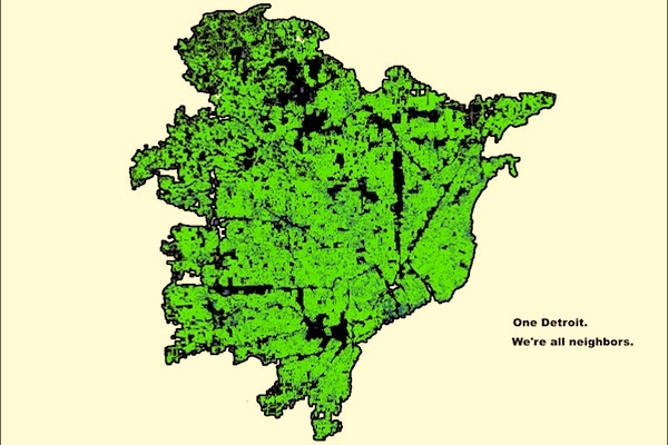
So what could One Detroit look like, without boundaries? Well, if we’re using the fairly straightforward metric of people living in close proximity to one another as a basis to form a municipality, one way to start could be this: What if we just drew a line around where people lived?
An awesome tool to visualize this idea, the “Synthetic Population Viewer” was recently released as a project of RTI (Research Triangle International) and the scary sounding Models of Infectious Disease Agent Study (MIDAS), which is funded by National Institutes of Health as a collaborative network of research scientists who use computational, statistical and mathematical models to understand infectious disease dynamics. This team used data from the American Community Survey, which is an ongoing sampling of U.S. Census data to drill down on things like age, sex, race and income level. It’s fascinating to virtually fly across the country and take snapshots of various places to get a sense of their makeup.
For Detroit, the actually scary (and sad) images show our region’s age, income and racial profile. But if you look at the household size, the distribution is fairly uniform, with a few exceptions. The number of people in each household is really not as important as showing people as neighbors in a region, where they live in significant numbers, and where they don’t.
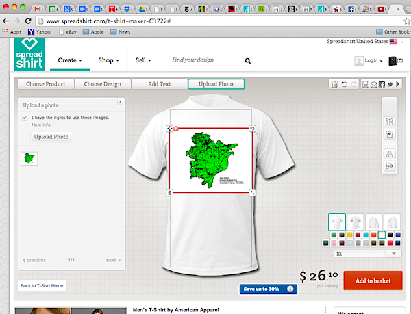
To see what One Detroit might look like, I did a little experiment of my own. Using the household size map as a base, and the free (but frustrating) open source GNU Image Manipulation Program, or GIMP, for short, I was able to create a new map of One Detroit, in a few easy steps.
Would it look good on a T-Shirt?
Francis Grunow is a citizen of One Detroit, as well as a partner at New Solutions Group, a public policy consulting firm going on three years in the Green Garage.
In the upcoming Part III of this three-part series on Detroit, our author looks (not that) far into the future and makes the case for why the whole country should not just care about Detroit, but invest in a more sustainable city, starting right now. Look for Part III on Feb. 5.
Related Articles

3+13 Ways to Celebrate 313 Day in Detroit
March 13th — known locally as 313 Day — is Detroit’s unofficial holiday celebrating the city’s area code, culture, and community pride.
Travel + Leisure Names Detroit, “Most Underrated City” in Midwest. Here are 5 Gems We Think Were Missed
Detroit’s renaissance is happening in every corner of the city, often in places that fly just a little under the radar. At Model D, we’ve had the chance to cover many of those emerging spaces, projects, and entrepreneurs shaping Detroit’s future. Here are five Detroit gems we think deserve a spot on any “underrated Detroit” list.
Detroit was once home to 18 Black-led hospitals – here’s how to understand their rise and fall
Detroit had approximately 18 Black-owned or Black-operated hospitals during the 1940s and ’1950s. Their decline followed structural and policy shifts. Hospital desegregation after World War II opened previously white-only hospitals to Black physicians and patients.
