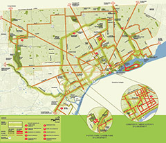
The Detroit Greenways Coalition has released a nifty map and guide to greenways that exist and are planned in Detroit, Highland Park and Hamtramck. Entitled "Building Pathways that Unite a City," the brochure unfolds to a full-color map that reveals off-road and on-road routes all over town, some denoted as existing, some as planned and a few that are merely conceptual at this time.
There are ten main greenways described:
- Conner Creek Greenway: Nine miles of pathways that will roughly follow the route of the former Conner Creek on the eastside, from the Detroit River to Eight Mile. Two miles are complete.
- Corktown-Mexicantown Greenlink: 16.25 miles that will connect Corktown and Mexicantown to each other and to the West Riverfront. The plan is complete and community groups are hoping to see construction begin this fall.
- Dequindre Cut: This two-mile rail-to-trail project will run two miles between the East Riverfront, Lafayette Park and Eastern Market up to Mack. 1.2 miles of it are complete and open to the public.
- Detroit RiverWalk: A stretch of public river access targeted to pedestrians and cyclists that will eventually stretch 5.5 miles between the Ambassador Bridge and Belle Isle; 2.7 miles are complete.
- Downriver Delta Greenways: Located in the 48217 zipcode on the lower Southwest side of Detroit, this 2.5 mile greenway will run along Fort Street into Downriver when built.
- Hamtramck Trail: This 1.5 mile route will connect Hamtramck's downtown to its parks. Eventually, hopes are to tie it into the Dequindre Cut on its south end.
- Inner Circle Greenway: Mostly conceptual at this time, the vision for the Inner Circle Greenway is a 20-mile route that would make use of the abandoned Detroit Terminal Railroad right-of-way. Picture a Dequindre Cut that take a roughly half-circle route through Detroit, Hamtramck and Highland Park.
- Midtown Loop: Work is expected to begin this summer on this two-mile loop through the Cultural Center. Future plans include connections to New Center and Downtown.
- Southwest Detroit Greenway: This 3-mile greenway connects Woodmere Cemetery, the West Vernor business district, Patton Park and Dearborn's Lapeer Park. Hopes are to run it further east to Clark Park in Mexicantown.
The purpose of the map is to inform, but also to "sell the vision," says Todd Scott of the Michigan Trails and Greenways Alliance, the organization that coordinates the Detroit Greenways Coalition. The target audience is residents, elected officials and funders.
Copies of the map will be available on the RiverWalk during the upcoming
RiverDays event, June 19-21.
Source: Todd Scott, Michigan Trails and Greenways Alliance
Writer: Kelli B. Kavanaugh
Enjoy this story?
Sign up for free solutions-based reporting in your inbox each week.